Pinehaven Flood Hazard Information Sheet and Map 8
Search in document library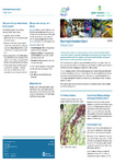
This information sheet covers the current flood hazard extent for the Pinehaven Stream Catchment that was identified in Phase 1 of the joint Upper Hutt City Council and Greater Wellington study. These maps may potentially change in the future, depending on the results of phase 2 of this investigation which is looking at potential flood mitigation and management options. This study is expected to be completed in approximately two years.